This was the second year of excavation as part of a three year Heritage Lottery funded project called ‘Woking Palace and its Park’, which will provide a rich variety of educational and community initiatives.
The medieval manor
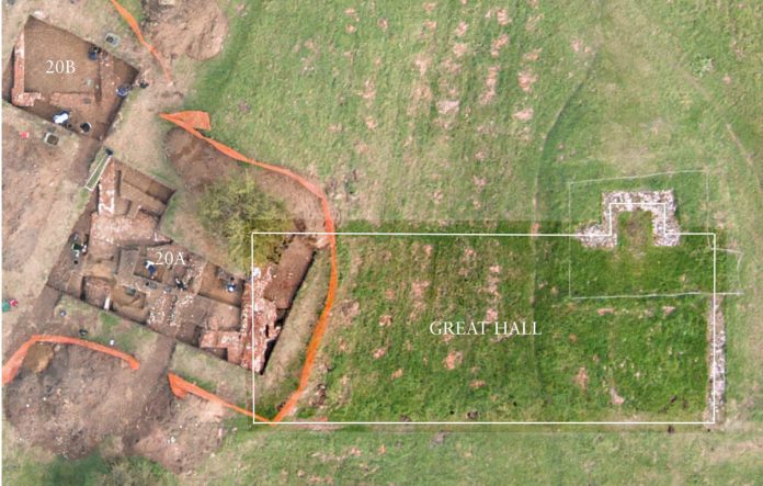
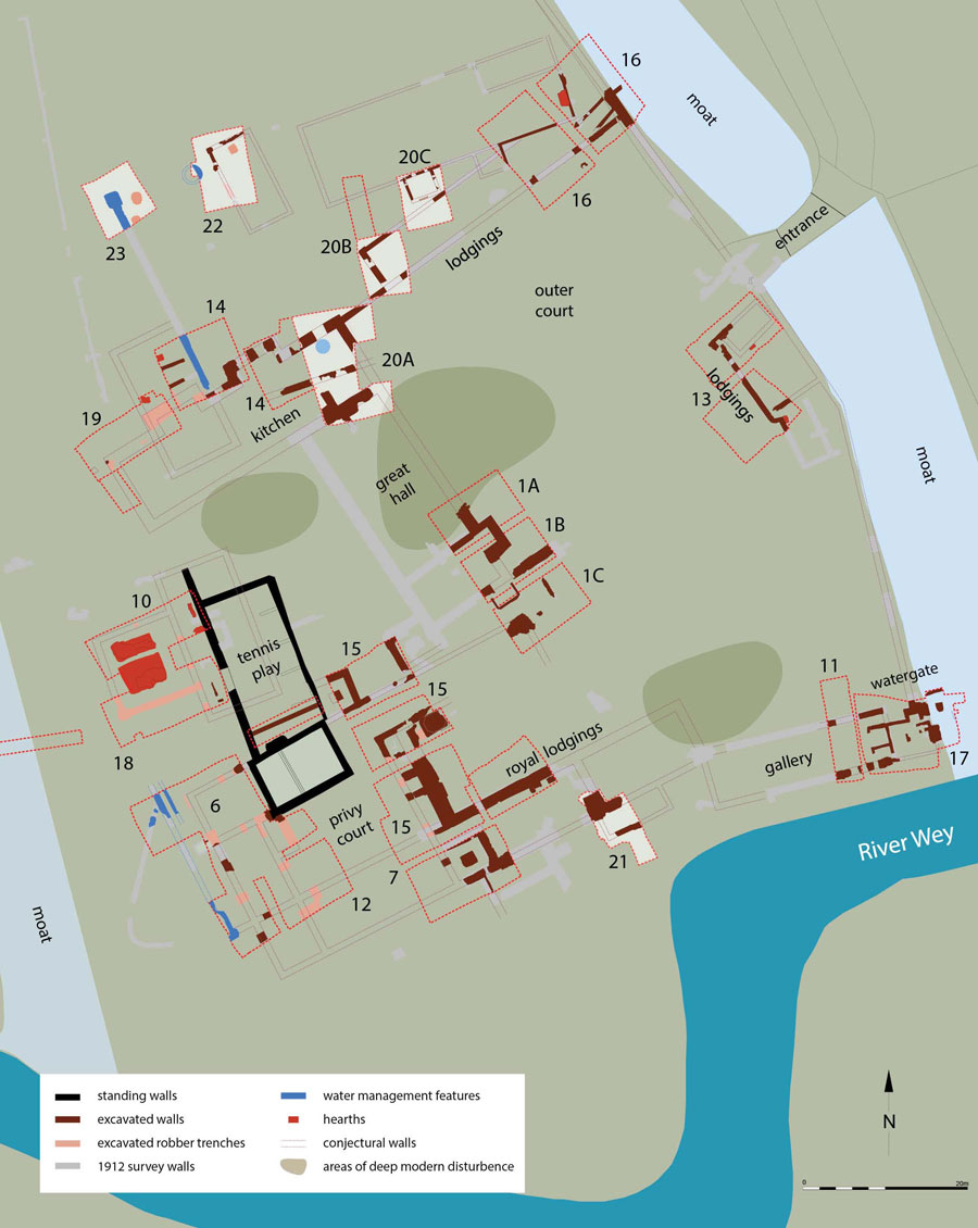
The excavations on the northern side of the complex revealed the foundations of a number of medieval buildings, all sharing a similar alignment that was quite different to that of the principal Tudor structures of kitchen, great hall and lodgings. In trench 20A a wall base composed of flint nodules and ferricrete blocks packed together had distinct layers to either side, with the cleaner layers to the south probably inside the building and those to the north, including heavily burnt deposits and containing much animal bone, representing refuse disposal outside. It seems likely that this was a medieval household kitchen replaced in a similar location by the brick-built Tudor one.
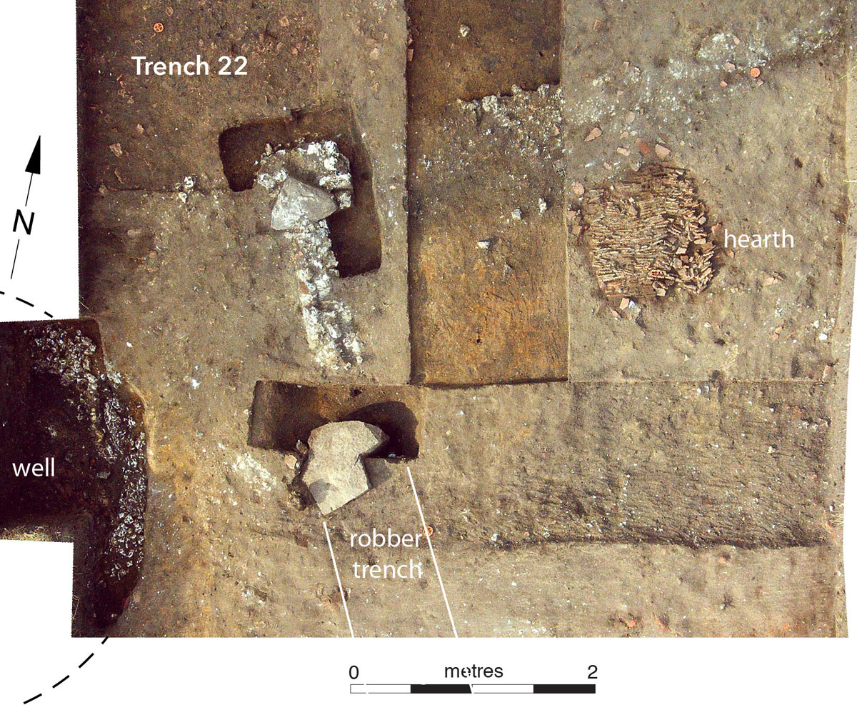
Parts of another medieval building were identified in trench 20C, with sill walls having a base composed of mortared flint nodules with roof tile laid flat above it, sometimes several courses thick, presumably a levelling layer onto which the timber frame was laid. In trench 22 a different building was identified. The north-western corner consisted of a large sarsen block mortared with a number of flint nodules to form a rectangle. It was of one build with a wall projecting south (of very similar form to the sill walls in trench 20C), which terminated originally in a further, and very large, sarsen block with a mortared rubble base. Beyond this a wide robber trench, that became shallower after around 3.5m, continued to the edge of the trench where it met another substantial sarsen block.
It seems probable that the deeper robbing relates to the preferential recovery of stonework, itself present because it supported, perhaps, a chimney breast serving a first floor fireplace. The north wall of the building was represented merely by a smear of mortar and chalk with occasional flint nodules, but its interpretation is confirmed by the contrast between layers to the north and the south of it, with a rectangular tile-on-edge hearth set close to the south side. The former interpretation of a large barrack-like building with attached stables extending across this area is clearly wrong, with at least two different buildings represented.
Tudor rebuilding
In trench 20A the massive brick walls of the east end of the new late 15th century kitchen were identified, showing very clearly the basic construction method of a series of rectangular piers between which the wall was supported on connecting arches. The piers were longer at the corners than elsewhere, and the arches were a flattened arc, of a thickness formed by two bricks laid lengthwise, created using sand as the arch former. The south wall had a projecting base for an entrance which would have led out to the medieval great hall. It was closed off by the creation of the new great hall of Henry VII, which was directly attached to the Tudor kitchen. The junction of these two buildings, where the southeast corner of the kitchen was, had unfortunately been entirely removed by later disturbance, but a wall within the great hall could be seen to butt up to the earlier kitchen wall. This internal wall lies at the mid point of the north end of the great hall, and the plan of excavations in the early 20th century shows a projection from an equivalent point on the dividing wall towards the south end of the great hall. It seems probable that there was a central division lengthways of the ground floor of the great hall, indicating that this functioned as an undercroft or cellar, with the hall proper at first floor level.
A brick wall was butted to the north-east corner of the kitchen, and formed the courtyard wall that extended eastwards to the moat. Its comparatively shallow foundations (around 0.90m below ground level) confirm it was a substantial but essentially freestanding wall. A structure was attached to its northern side, represented partly by a robber trench and partly by brick foundations, which were no more than two courses deep as they survived. In places the evidence for this structure had been totally removed, although there was no indication of deep disturbance, and this might explain the difficulty in tracing this wall elsewhere, and also raises the possibility of buildings for which the evidence could have been totally lost. The size of the foundations indicates a timber-framed structure, while the existence of what are effectively clasping buttresses at the north-west corner suggests that a half-timbered form is likely for these lodgings.
A more impressive set of lodgings, almost certainly built for royal use in the late 15th century, has been previously explored on the south side of the complex, and trench 21 was intended to clarify their form. The presence of trees and associated rooting hampered investigation but a rectangular brick platform was identified, which was butted up to a substantial east-west wall to the south, and was itself overlain by a north-south wall that also butted to the east-west wall.. The sequence is intriguing, but the similarity in appearance and brick types of the three wall elements suggests that it represents stages in construction rather than phases of building. The platform seems likely to have been the support for a fireplace and/or garderobe at first floor level, while the north-south wall is an internal partition. A further east-west wall ran parallel to the main wall some 2.5m to the south. Its odd construction method, with two layers of randomly coursed brick separated by a mass of mortar and brick rubble, suggests that it was not the base for a major load bearing wall, and could either be the footing for a single storey brick wall or the sill base for a timber frame. The form of the footing in either case is likely to have been a response to the soft and frequently waterlogged soils in this riverside location. These walls indicate that the previously suggested overall form of the buildings in this area requires substantial revision.
Wells, water and industry
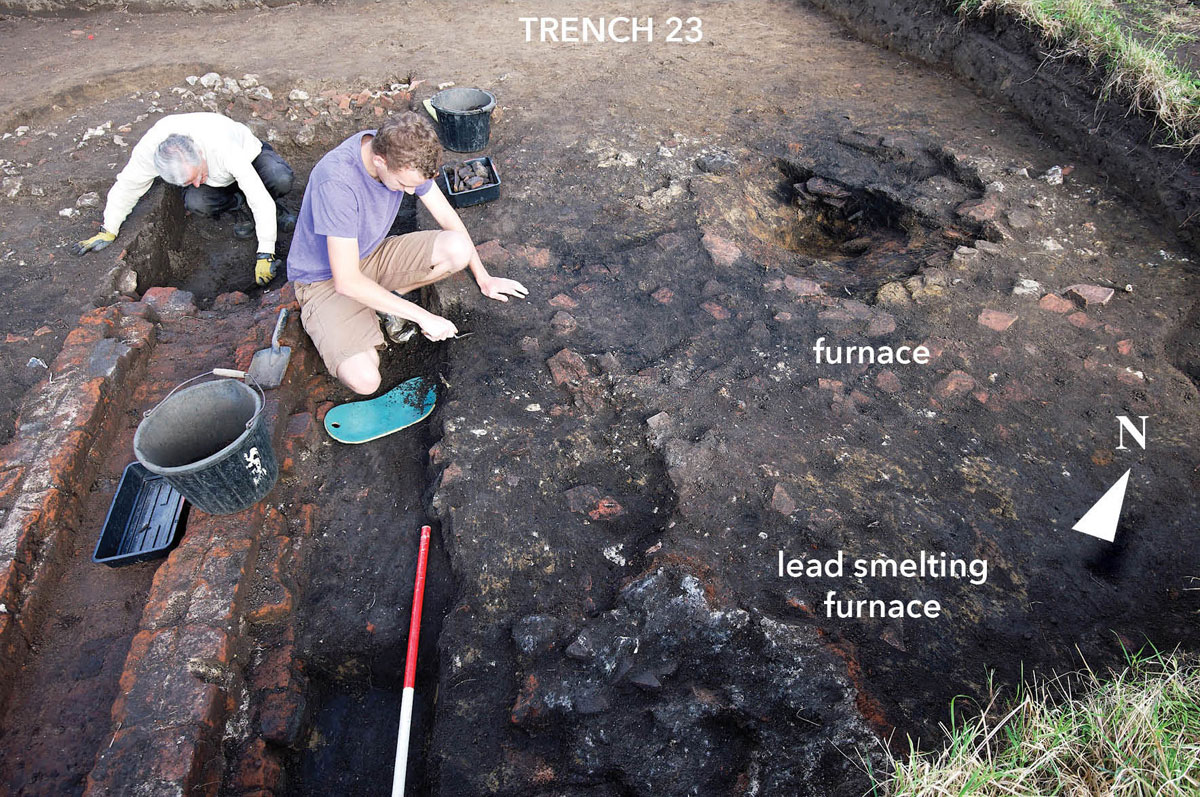
A well (or, perhaps, the shaft for a pump) had been infilled in conjunction with the construction of the Tudor kitchens and was presumably associated with the medieval kitchen to its south. It might also have supplied water for the industrial activities that were identified in trench 23. These included, as well as spreads of heavy burning, a pit with heavily burnt sides whose purpose is unclear, and a small bowl-shaped lead smelting furnace with melted lead at its base and scrap lead in and around it. A brick channel had been cut through some of these layers but was contemporary with others, and was connected to the Tudor kitchen at one end and to a large pit within the trench. The pit formed a flattened oval around the terminus of the channel and had steep sides and a level bottom.
The channel was undoubtedly carrying something from the kitchen. One possibility is that waste water from the kitchen was discharged in this way, but the pit seems inadequate as a sump since it would rapidly have clogged with a festering mass of waste and, if this had been the intention, then a continuation of a few metres for the channel would have enabled it to discharge into the moat, a much superior and commonly used means of disposing of such material. The most plausible explanation is that it was bringing water from a cistern in the Tudor kitchen, which discharged into a tank, either of wood or lead, in the pit, with the intention being to supply water for the industrial activities in this area. The pit was infilled with demolition debris, especially notable for a collection of medieval patterned tiles, of 14th century Penn (Bucks) types, as well as a single Valencian tile. The atypical character of this demolition deposit suggests the possibility that it was created during remodelling of a medieval building in the lifetime of the palace.
The need for water after it was taken out of use may have been met by digging a well a few metres to the east, at the west side of trench 22. This was only identified right at the end of the excavation and was lined with large chalk blocks with an internal diameter of just over 2m, and a depth, tested by coring, of around 3.5m from ground level. Its construction and dimensions could indicate that it is the well built for Elizabeth I in 1579, ‘a well in the back court to serve the kitchen and offices, being 7 feet wide and 12 feet in depth’ (pers comm Richard Savage; TNA E 351/3214, transcription by Richard Christophers), although there is no clear basis for phasing the well from the excavations.
The excavations at Woking Palace in 2014 continued to refine, and in some respects radically alter, understanding of the development of the manor and palace. Further consideration of some issues is needed (notably the seeming excess of kitchens!), while others may be clarified by the final season of excavation in September 2015.
The Project
A key part of the project was giving members of the public a chance to become involved in the excavations and a public Open Day also offered over 400 visitors a tour, led by a Friend of Woking Palace, around the various trenches, where the discoveries were explained by some of the many archaeologists who had worked on the site. More formal training in archaeological skills was also offered.
Woking Palace and its Park – Main website
The excavation was only possible as a result of the efforts of a large number of organisations and individuals.
We are grateful to them all but more specifically thanks are due to Woking Borough Council, the owners of the land; to the Department of Culture, Media and Sport (acting on the advice of English Heritage) for granting consent for work involving a Scheduled Ancient Monument (No 12752), and to those who took the lead roles in organising and assisting the excavation work: most particularly Pete Smee and Jean Follett (FoWP); the finds team, ably led by Ann Harvey; and Hannah Potter (Community Archaeologist), Nigel Randall (skills training) and Giles Pattison (site planning and photography) of Surrey County Archaeological Unit.
The technical expertise and assistance provided by Archaeology South-East (University of London) and QUEST (Quaternary Scientific, University of Reading) is also acknowledged.


